
Islands


Japan is an archipelago, so it's only logical that there are names for the different islands it consists of. There are four main islands: Hokkaido in the north, Honshu is the big main island below that, Shikoku underneath the west end of Honshu, and Kyushu off the west end of Honshu. There's also the Ryukyu Islands that stretch southwest of Kyushu—Okinawa is a part of these—and a collection of small islands far to the south of Honshu, which contains Iwo Jima.
Regions
It starts to get confusing here. Regions are the next step down, although really only with respect to the island of Honshu. The other islands are simply their own regions, except the Ryukyu islands usually get lumped in with Kyushu. As far as I can tell, regions serve no purpose other than to make it easier to give weather reports. All government entities are divided by prefecture (see next section) below the national level. AJET, however, does organize events for JETs by region sometimes, but they are usually not entirely exclusive like some of the prefectural events can be.

Honshu contains 5 main regions. Starting north and moving southwest they are: Tohoku (green), Kanto (blue), Chubu (orange), Kansai (teal), and Chugoku (green). Kansai region is also known as Kinki. For reference, Fukushima is in Tohoku region, Tokyo is in Kanto region, Mount Fuji is in Chubu region, Hiroshima is in Chugoku region, and Osaka, Kyoto, and Kobe are in Kansai region.
Prefectures
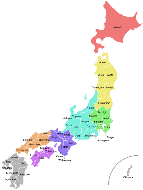
More confusion coming at you. Most regions are divided into several prefectures, with the one exception to the north, Hokkaido. It is an island, region, and prefecture all at the same time. There are 47 prefectures in Japan, so I won't bother naming all of them. Prefectures have their own governments, including a Board of Education. As a JET that teaches at a senior high school, I am employed by the prefectural Board of Education.
Cities, Districts, etc.
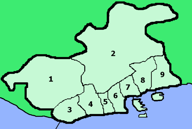
Taking Hyogo Prefecture as an example, prefectures are further divided in a few different ways. The most common is cities. The pink divisions you see are the cities of Hyogo. There are certain requirements an area must meet to be called a city, although this isn't always the case; cities are supposed to have a population of at least 50,000 people, and though where I live is called a city, its population is only 42,000.

The beige or tan divisions are districts. These are basically remnants of Japan's older system of districts, towns, and villages. Over the past few years, a number of areas (including where I live) have undergone a process in which a collection of villages and towns in a district "merge," and the district becomes a city. The areas that are still districts either simply don't have the population, or have not made a move to merge towns/villages yet.
Designated Cities, Core Cities and Special Cities
The purple division you see bottom-right in the above picture is Kobe, and it is what's called a designated city. These are usually the biggest cities within a prefecture (often prefectural capitals), and they are delegated certain prefecture-wide responsibilities. Because they are so big, designated cities are further divided into wards. You can see the different wards of Kobe below.
There are also cities that are called core cities and special cities. Core cities are smaller than designated cities, but they are also given prefectural responsibilities. Finally, special cities are even smaller than core cities, but are delegated certain jobs that core cities have control over. Therefore, the order is designated first, core second, and special third. Neither core cities nor special cities are split into wards like designated cities are, as they are generally not big enough.
Special Wards in Tokyo
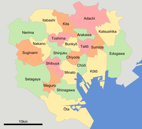
To no surprise, Tokyo is an outlier in all of this. The Tokyo Metropolis area is divided into 23 "special" wards. They operate essentially like the wards of other big cities—so they share a number of public services like water supply, sewage, and fire departments—but they are more autonomous in the legal sense, like regular cities.
Our Tokyo Orientation was held in Shinjuku, which while far from the most populous ward of the metropolis, it is certainly the most urbanized and commercialized, containing the headquarters for many large businesses, as well as the busiest train station in all of Japan (and supposedly the world). Setagaya is the most populous, holding well over 800,000 residents compared to Shinjuku's 300,000.
If I discover more details about Japan's geography, I'll be sure to update this page.
No comments:
Post a Comment